Hurricane Info

Universal Time Coordinated
 *******Tracking***********
NO STORMS
Website Time
 2024 Atlantic Hurricane Season Names:
Alberto Beryl Chris Debby Ernesto Francine Gordon Helene Isaac Joyce Kirk Leslie Milton Nadine Oscar Patty Rafael Sara Tony Valerie William
Live Atlantic Loop


active storms will be seen here


WHAT ARE SPAGHETTI MODELS? spaghetti-models-300x248jpg

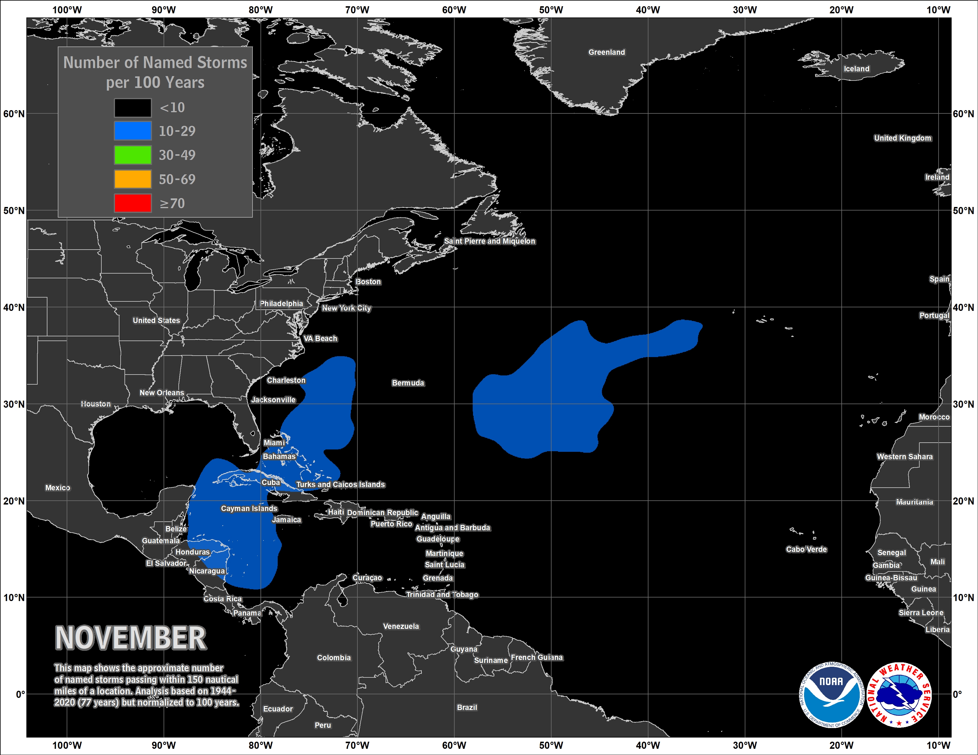
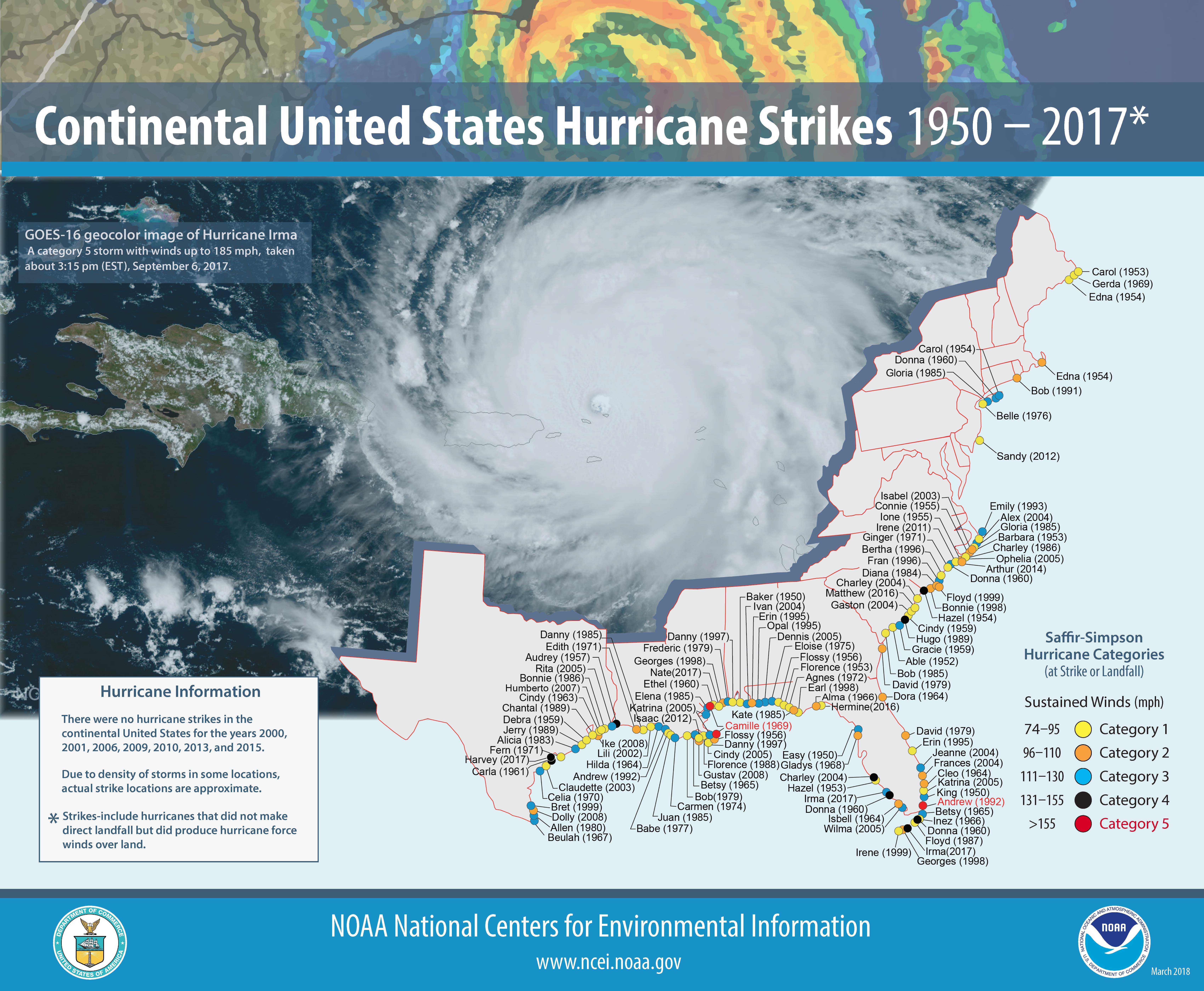
Spaghetti models (also called spaghetti plots, spaghetti charts and spaghetti diagrams) is the nickname given to the computer models that show potential tropical cyclone paths. In short, spaghetti models give you a way to see where a tropical storm or hurricane may head( they update every few hours). It can also give insight into whether the models are in agreement on the path of the storm or if there is a wide differing opinion on where the storm may go.

Spaghetti models are also useful in the case of a developing storm system that has not officially become a tropical depression or a tropical storm, meaning that no agency has released an official path but the system has tagged as an investigation area (Also called an invest). In these instances, spaghetti models can serve to give you an early heads up as to where a future tropical storm or hurricane may head.

However, once a tropical disturbance has officially become a tropical cyclone, different government agencies (e.g. the National Hurricane Center for the Eastern Pacific and Atlantic basins) release an official best guess path based on their analysis of the different model data and other factors. These forecasts should be used for official planning, though the spaghetti plots can still be quite useful for seeing how confident all of the models are.

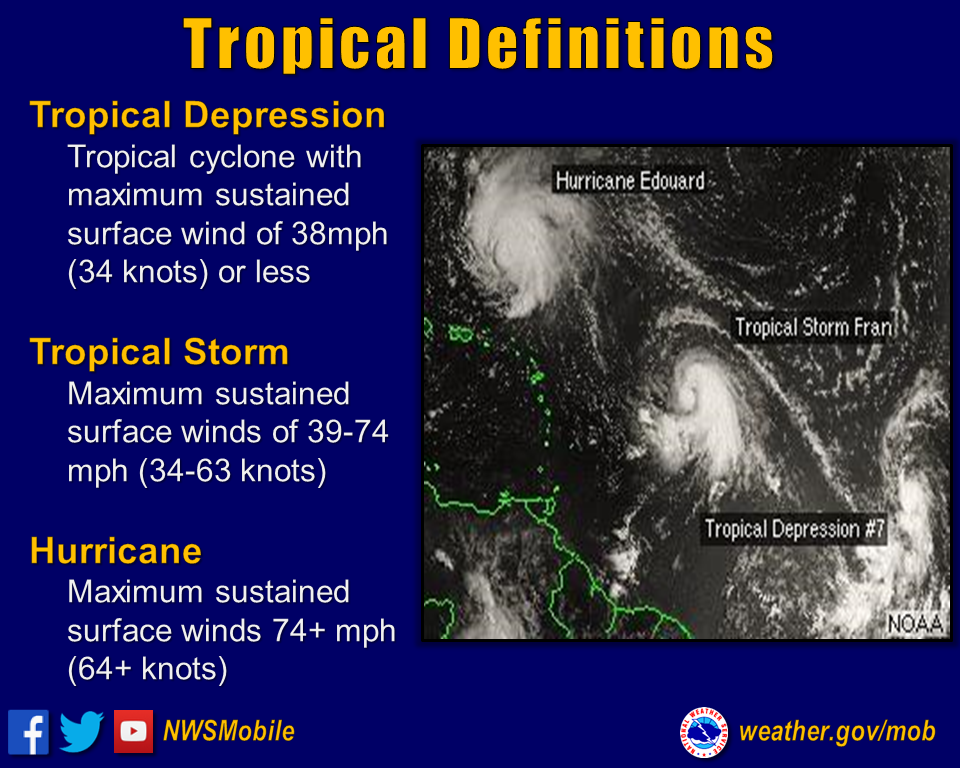
Please note that these models do not speak to whether a storm will bring rainfall, hurricane-force winds, surge, or other data; they just contain information about the center of a storm’s future track. An additional limitation spaghetti models have is that they don’t show any representation of intensity or size of a particular storm. These are represented on different charts, usually for individual storms.


What Does Invest mean ?

An Invest (short for Investigation), also called an area of interest, is a designated area of disturbed weather in the tropics investigated by the National Hurricane Center (NHC).

The term Invest is followed by the numbers 90 through 99 and either the letter “L” for the Atlantic basin systems or “E” for the eastern Pacific systems. . once 99 is reached , it recycles and goes back to 90.. So if you see invest 90L, that means there is an area in the Atlantic being monitored . if it says invest 90E , there's a system in the Pacific being monitored ..Hope this helps


What Actions Should You Take To Be Prepared: Have a Family Disaster Plan and Disaster Supply Kit. Build or identify a Safe-Room in your Home. purchase a NOAA Weather Radio with a tone alert feature, which allows you to receive warnings by your local NWS office. Inquire if your Community is StormReady.
Upcoming tropical names 
True Color GOES 16 View
Atlantic Hurricane season begins on June 1st and ends on November 30th

The Atlantic hurricane season is the period in a year when hurricanes usually form in the Atlantic Ocean. Tropical cyclones in the North Atlantic are called hurricanes, tropical storms, or tropical depressions. In addition, there have been several storms over the years that have not been fully tropical and are categorized as subtropical depressions and subtropical storms. Even though subtropical storms and subtropical depressions are not technically as strong as tropical cyclones, the damages can still be devastating.
What is a Hurricane?
A tropical cyclone is a rapidly rotating storm system characterized by a low-pressure center, a closed low-level atmospheric circulation, strong winds, and a spiral arrangement of thunderstorms that produce heavy rain or squalls.
Tropical Storm?
Organized system of strong thunderstorms with a defined surface circulation and maximum sustained winds of 39-73 mph.
Hurricane?
Intense tropical weather system of strong thunderstorms with a well-defined surface circulation & max sustained winds of 74 mph or higher.

What should I do with a Watch or Warning? 
When a Hurricane Watch is issued for your part of the coast this indicates the possibility that you could experience hurricane conditions within 48 hours. This watch should trigger your family's disaster plan, and proactive measures should be initiated especially those actions that require extra time such as securing a boat, leaving a barrier island, etc.
When a Hurricane Warning is issued for your part of the coast this indicates that sustained winds of at least 74 mph are expected within 36 hours. Once this warning has been issued, your family should be in the process of completing proactive actions and deciding the safest location to be during the storm. 
 Hurricane Hazards?
Storm Surge: Water that is pushed toward the shore by the force of the winds swirling around the storm. This advancing surge combines with the normal tides to create the hurricane storm tide, which can increase the mean water level 15 feet or more.
Inland Flooding: In the last 30 years, inland flooding has been responsible for more than half the deaths associated with tropical cyclones in the US.
High Winds: Hurricane force winds can destroy poorly constructed buildings and mobile homes. Debris such as signs, roofing material, and small items left outside become flying missiles in hurricanes.
Tornadoes: Hurricanes can produce tornadoes that add to the storm's destructive power. They are most likely to occur in the right-front quadrant of the hurricane.
                                             OIPffjpg

untitled severe weather png

BeaufortScalejpggif